Have you ever dreamed of packing up and road tripping for months on end?
Nick Paquette, a freelance video editor, did just that last year. He embarked on a road trip across North America and drove over 21,700 miles in six months, discovering some of Canada and America’s most scenic attractions on the journey.
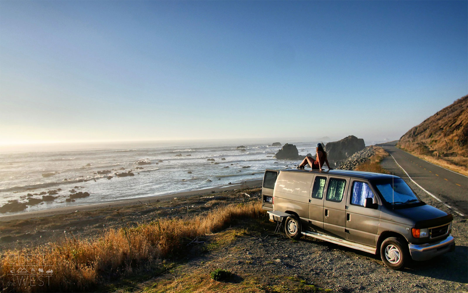
Paquette and his girlfriend originally decided to take the trip as a way to explore their homeland Canada and later extended the trip to include the U.S.
The couple purchased a Ford Econoline E150 from a used car dealership for around $5,000 and converted it into a makeshift home, choosing to do the trip by car so they would have the freedom to venture anywhere they chose over the next six months.
The duo explored everything from remote surf towns and tranquil campgrounds to adventure-packed caves, sharing the must-see locations with Travel + Leisure. From emerald-colored lakes to valleys blanketed in golden trees, here are the top North American destinations Paquette says you won’t want to miss when taking your own journey.
Courtesy of Nick Paquette
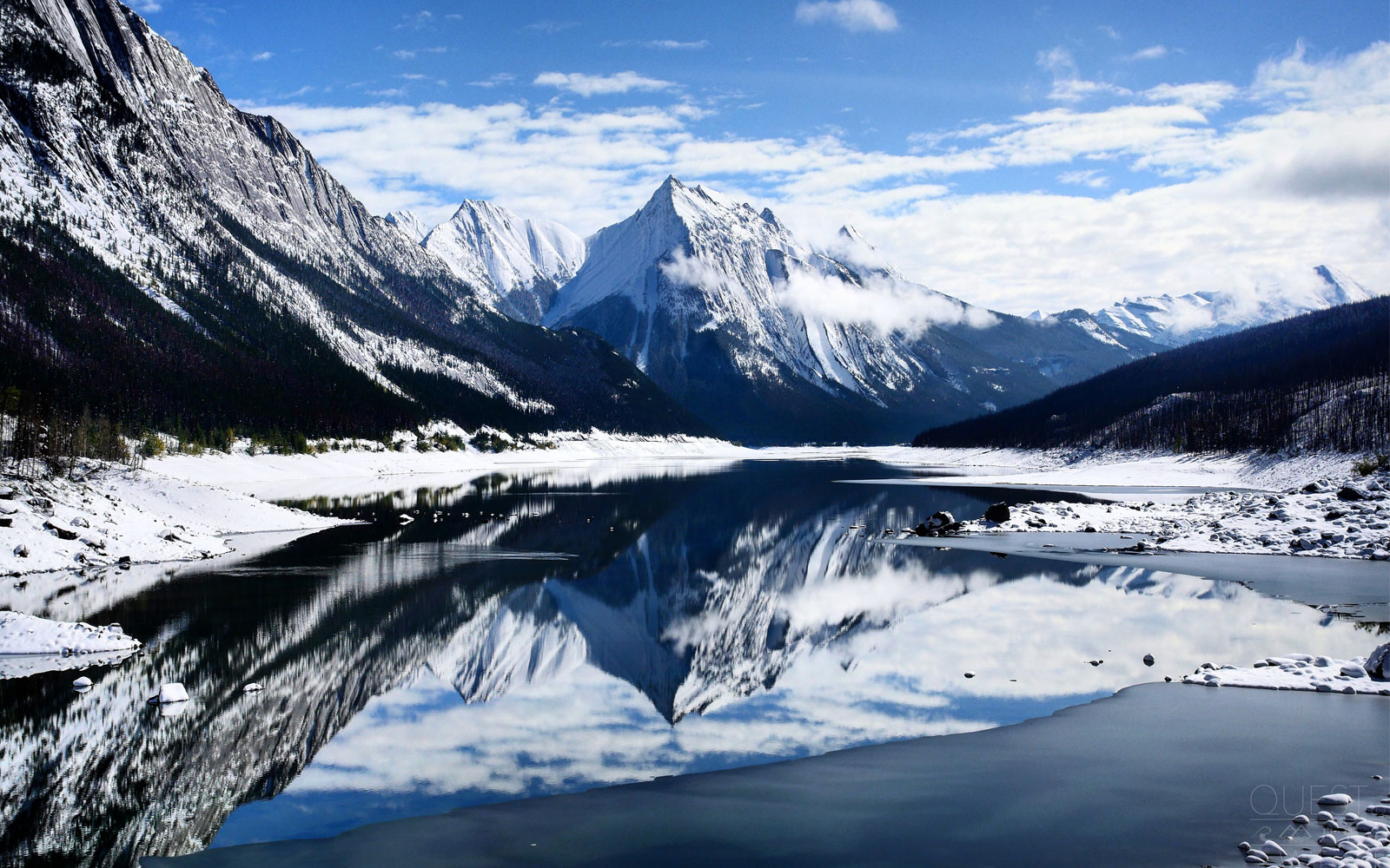
Medicine Lake — Alberta, Canada
Paquette and his girlfriend started their trip in Ontario and headed north until they reached Alberta, where the duo stopped to admire the scenery of Medicine Lake, located in Jasper National Park. Glacial waters feed the lake in the summer, making levels so high that, at times, it can overflow before it dries out in the winter into a mudflat.
The water actually drains out of the lake from the bottom through sinkholes, like a giant bathtub and then travels through a 10-mile series of underwater caves, resurfacing at the Maligne Canyon.
Courtesy of Nick Paquette
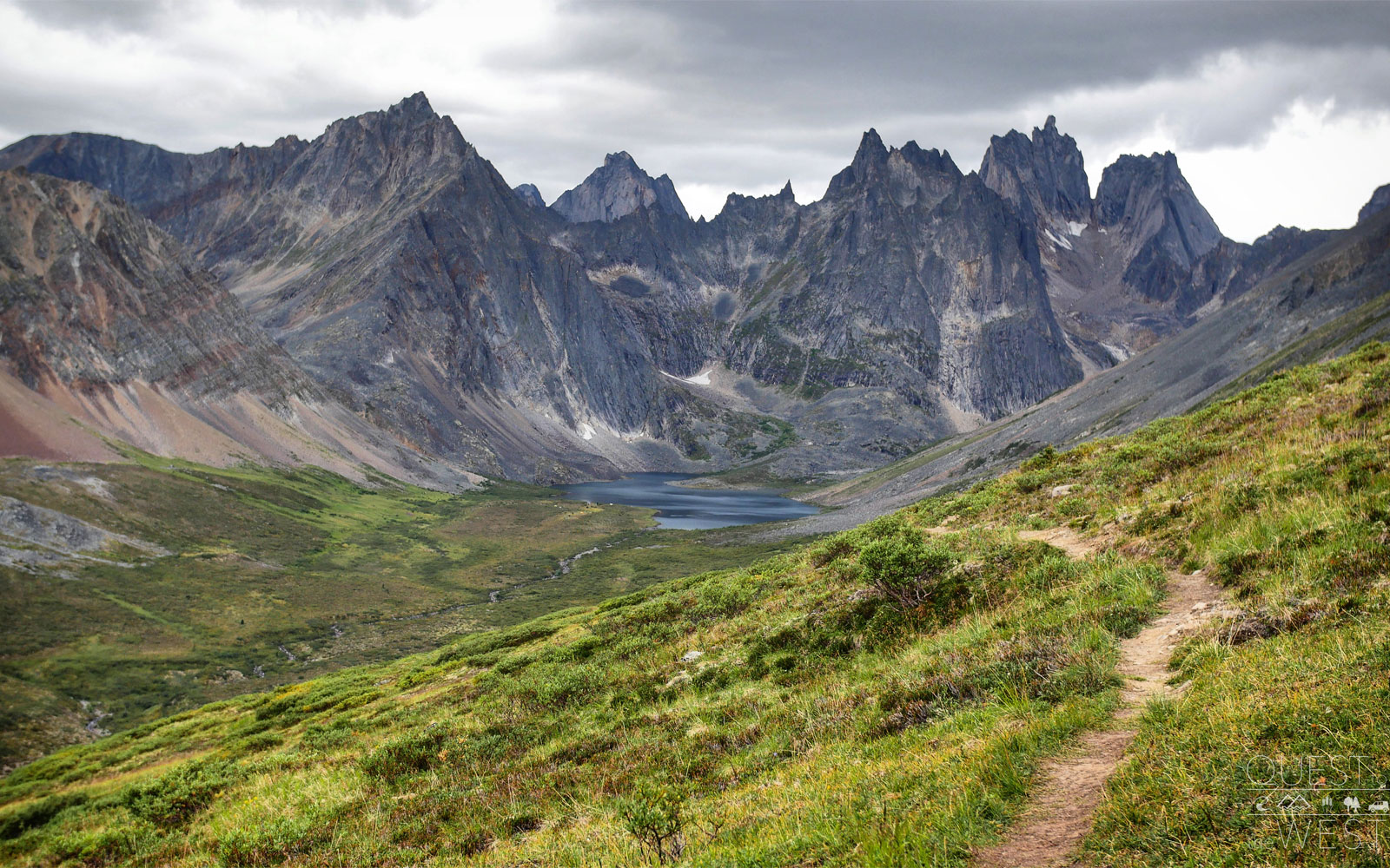
Tombstone Territorial Park — Yukon Territory, Canada
The two skipped Banff National Park to catch Canada’s Yukon territory while the weather was still warm. The area turned out to be Paquette’s favorite.
“Yukon was always a mystery to me because it’s so far north and isolated from everywhere else in Canada,” he told T+L. “The landscapes here were insane since everything is so spaced out and you have nature that’s much more intact with less human pollution.” One of their stops in Yukon was Tombstone Territorial Park, which is known as the “Patagonia of the North” thanks to its striking combination of peaks and tundra terrain.
“It’s where the forest and the tundra meet and once you go any farther north, the forest starts turning into tundra and you can’t see a single tree in sight, but you see rows and rows of these spiky towering mountains that surround you,” Paquette said of the Tombstone Mountains.
Courtesy of Nick Paquette
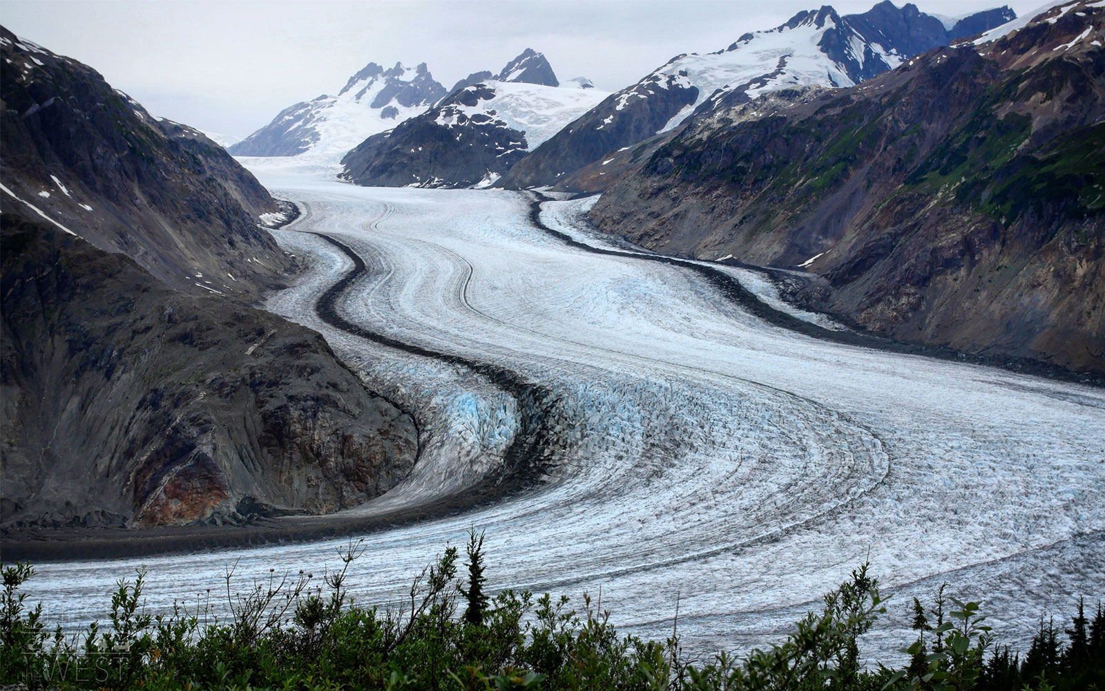
Salmon Glacier — British Columbia, Canada
In western British Columbia, the couple explored massive glaciers like Salmon Glacier, Canada’s fifth largest glacier and the world’s largest glacier accessible by road.
Thanks to its massive scale, those who visit the glacier, which sits north of both Stewart in British Columbia and Hyder, Alaska on the Canada-U.S. border, are rewarded with a striking view.
“When you get to the end of the road, you look down and there’s a massive glacier ahead of you, but the scale of it is so huge that you don’t even realize the crevices on it until you start to look closer,” Paquette said.
Courtesy of Nick Paquette
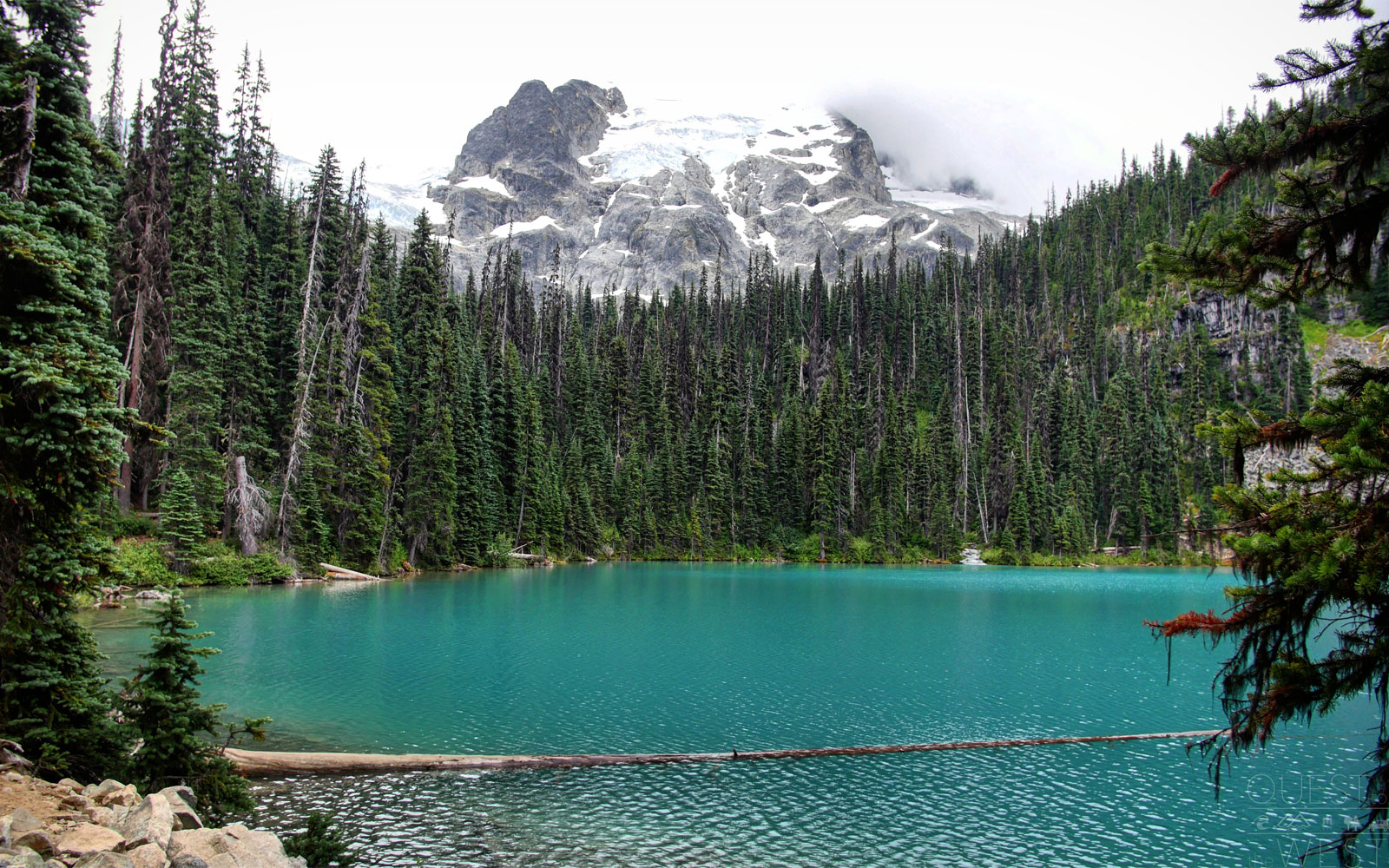
Joffre Lakes Provincial Park — British Columbia, Canada
Joffre Lakes Provincial Park features hiking a trail past three three turquoise lakes, which Paquette said appear increasingly brighter the higher you hike.
Park representatives say the bright hue is the result of “rockflour” (glacial silt) in the water that reflects blue and green light wavelengths from the sun to create the striking color.
Courtesy of Nick Paquette
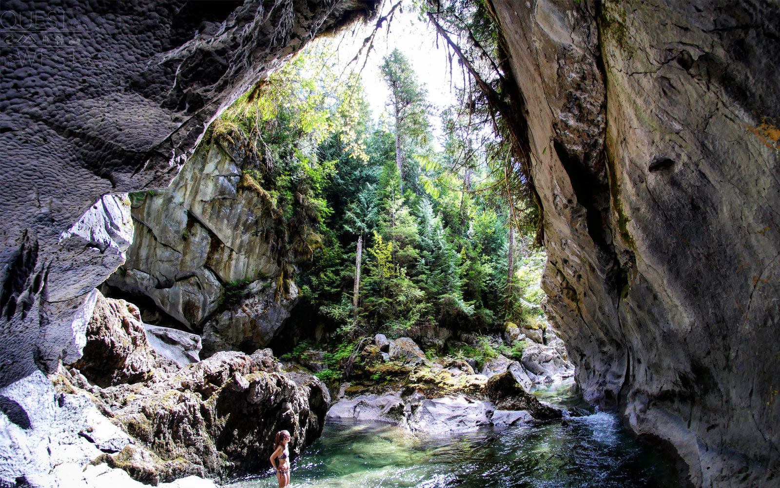
Little Huson Cave Regional Park — Vancouver Island, British Columbia, Canada
In Vancouver Island, the couple stopped at Little Huson Cave Regional Park. The park features limestone and rock arch formations, deep pools, and a variety of tunnels that have creeks flowing for as long as 60 meters (196 feet) underground.
Courtesy of Nick Paquette
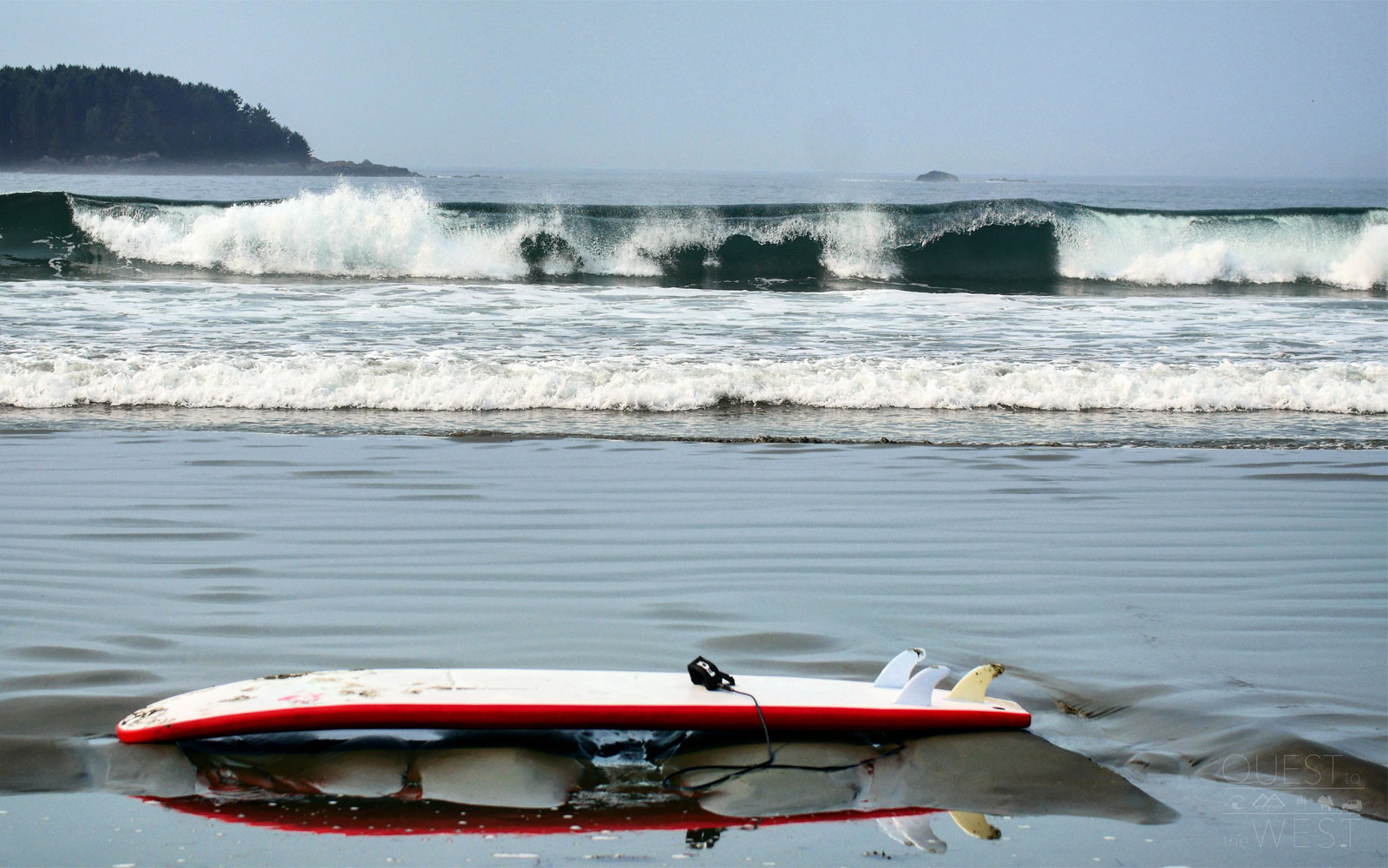
Tofino — Vancouver Island, British Columbia, Canada
Tofino, located on the remote west coast of Vancouver Island, is known as a premiere location for surfers.
Oceanside restaurants and beachside picnics are the norm here, while a buzzing art scene has led to streets dotted with galleries.
“This is one of the only places in the world where you don’t really get sick of going into the souvenir shops because you can tell everything is made locally, from their art prints to sculptures made using drift wood from the area,” Paquette said.
Courtesy of Nick Paquette
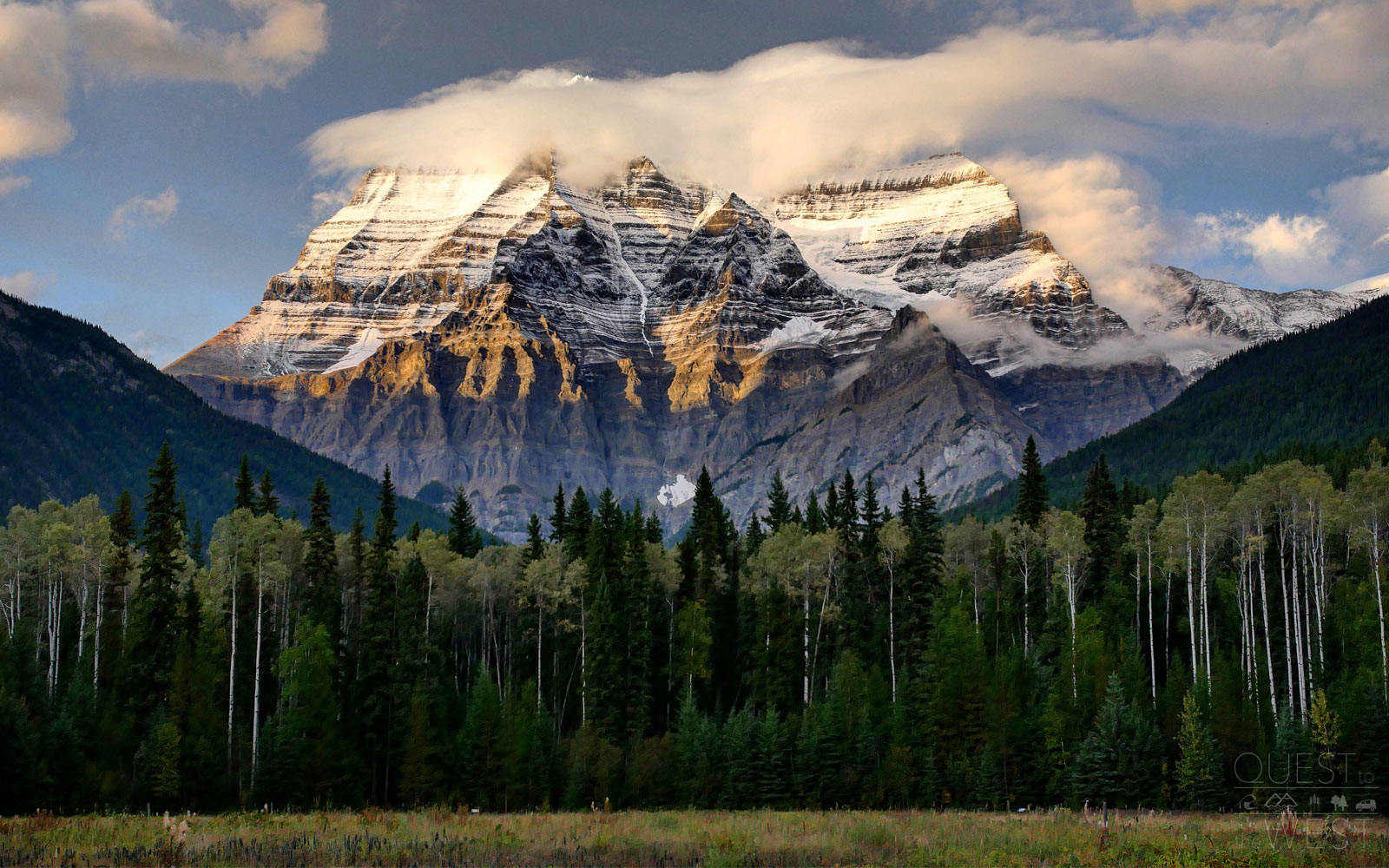
Mount Robson — British Columbia, Canada
The couple got their first view of Mount Robson while heading north toward Jasper National Park.
The towering mountain, which is the highest peak in the Canadian Rockies, was shrouded in clouds when Paquette and his partner approached it. They had to wait three hours to see its peak emerge as the surrounding clouds dissipated.
The mountain sits within the Mount Robson Provincial Park, which is the second oldest provincial park in British Columbia, and is home to everything from glaciers and lakes to waterfalls, canyons, and limestone caves.
Courtesy of Nick Paquette
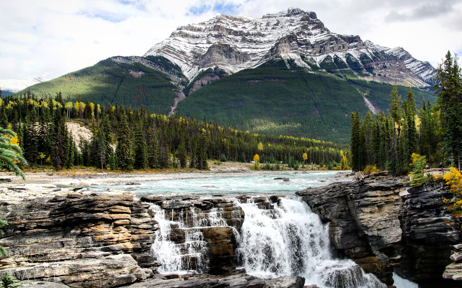
Athabasca Falls — Jasper National Park, Alberta, Canada
The Athabasca Falls in Jasper National Park are some of the most powerful in the mountain national parks, according to park representatives, and have cut into the limestone underneath to create natural formations like canyons and potholes.
“It’s a really picturesque part of Jasper as you’ve got the trees that are changing color, the falls, and if you look directly up, you’re surrounded by mountains around you,” Paquette said of the scenery.
Courtesy of Nick Paquette
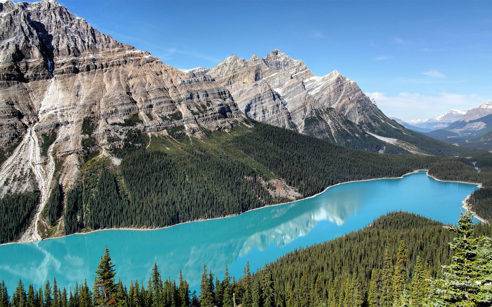
Peyto Lake — Banff National Park, Alberta, Canada
Paquette said he was taken aback by the color of Peyto Lake in Banff National Park.
“It’s the bluest lake you’ve ever seen because it’s so high up,” he said.
“The higher up you are looking down on it, the more blue it seems, and everything just looks so pure,” Paquette said. “Even though you’re surrounded by all the tourists who come to see the park’s beauty, everything around you here still looks like it’s never been touched and that it’s a rugged landscape humans don’t belong in.”
Courtesy of Nick Paquette
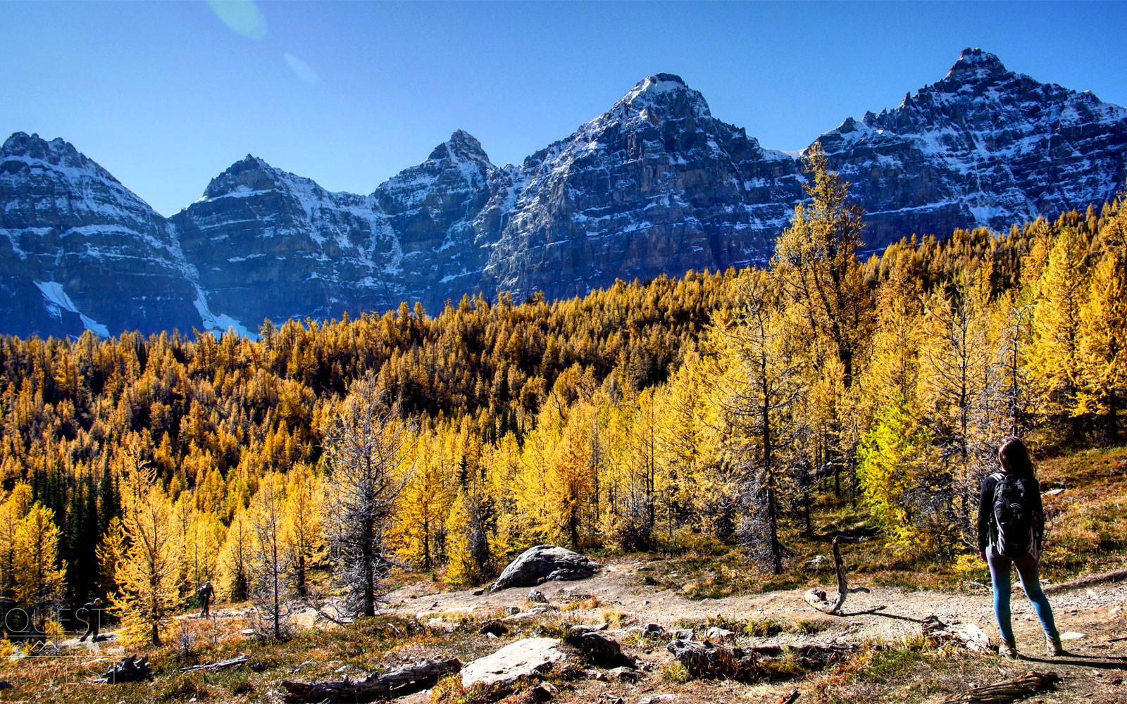
Larch Valley — Banff National Park, Alberta, Canada
In the fall, Banff National park’s Larch Valley is adorned with mesmerizing foliage.
The larch trees’ needles turn a bright gold for a few weeks each year, attracting thousands of tourists. Larch Valley, found through a trail above Moraine Lake, is further enhanced by its striking backdrop of white glaciers and towering peaks.
Courtesy of Nick Paquette
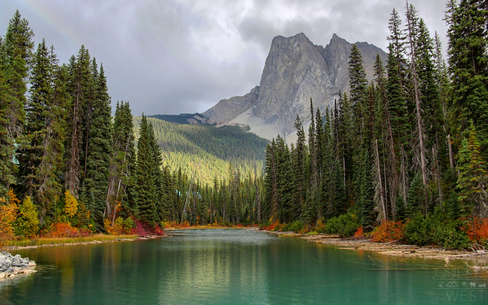
Emerald Lake — Yoho National Park, British Columbia, Canada
On the way out of Banff, the couple visited Emerald Lake at Yoho National Park.
“What we saw were the nicest colors in the entire park as the water is incredibly blue and you have all of these oranges, yellows, and reds that surround you from the nearby trees,” Paquette told T+L.
Although the lake is the largest in the park, it’s less known than its more popular counterpart, Lake Louise, so you’ll get to enjoy the dreamy green hues and picturesque mountain scenery among a smaller crowd.
Courtesy of Nick Paquette
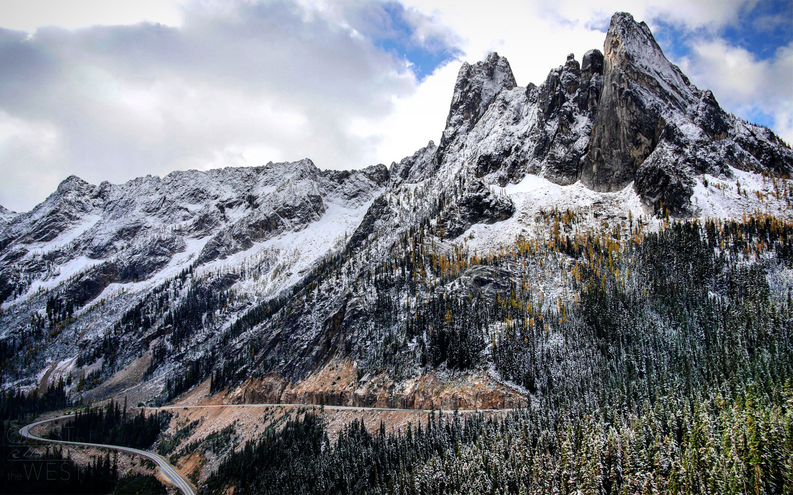
Washington Pass — North Cascades National Park, Washington
One of the first sites the couple saw in the U.S. was Washington Pass, situated right before North Cascades National Park.
“The pass is your first view into this huge mountain range, and from here you start on a winding road that’s filled with vegetation as you make your way into the park,” Paquette said.
The trail will take you up to an observation site where you’ll be able to see sweeping views of Liberty Bell Mountain, Early Winters Spires, and Kangaroo Ridge.
Courtesy of Nick Paquette
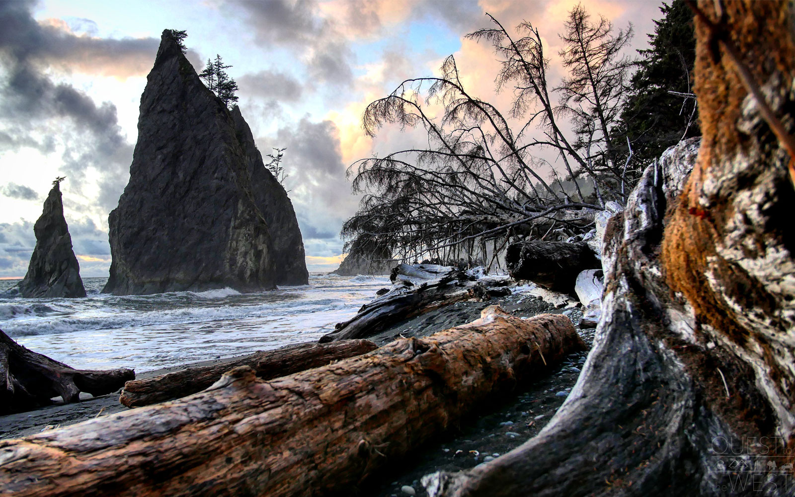
Rialto Beach — Olympic National Park, Washington
Olympic National Park offers its visitors three different ecosystems — rainforest terrain, mountain territories, and coastal beaches — within one park.
One of Paquette’s favorites was Rialto Beach, where massive driftwood decorates the landscape.
“You would see these massive trees that had drifted onto the beach years ago and have been there ever since, going all the way down the shores,” Paquette said.
Courtesy of Nick Paquette
The Lost Coast — California
One of the drives the couple took as they made their way south to explore America’s national parks was the Lost Coast. The region, which stretches down 650 miles of the California Coast, has no major access roads, giving it its name.
While the duo reached the Lost Coast via a road through the forest and mountains, visitors can also explore the area by foot.
Hiking the trail will take three to four days each way, but along the way you’ll be able to explore wild untouched beaches and dreamy coastal views.
Courtesy of Nick Paquette
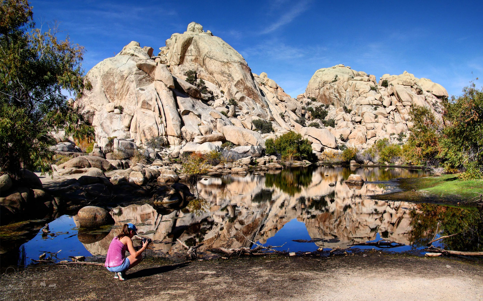
Barker Dam — Joshua Tree National Park, California
Joshua Tree National Park can be an incredibly dry environment, which is why Barker Dam offers such a surprising respite in the park. The dam brings with it its own set of freshwater species to admire, while giving you a different view of the park.
“The water creates a perfect reflection of the rocks that sit in front of it,” Paquette said of the tranquil refuge.
You can reach the dam by taking the Barker Dam trail, which is less than two miles in total.
Courtesy of Nick Paquette
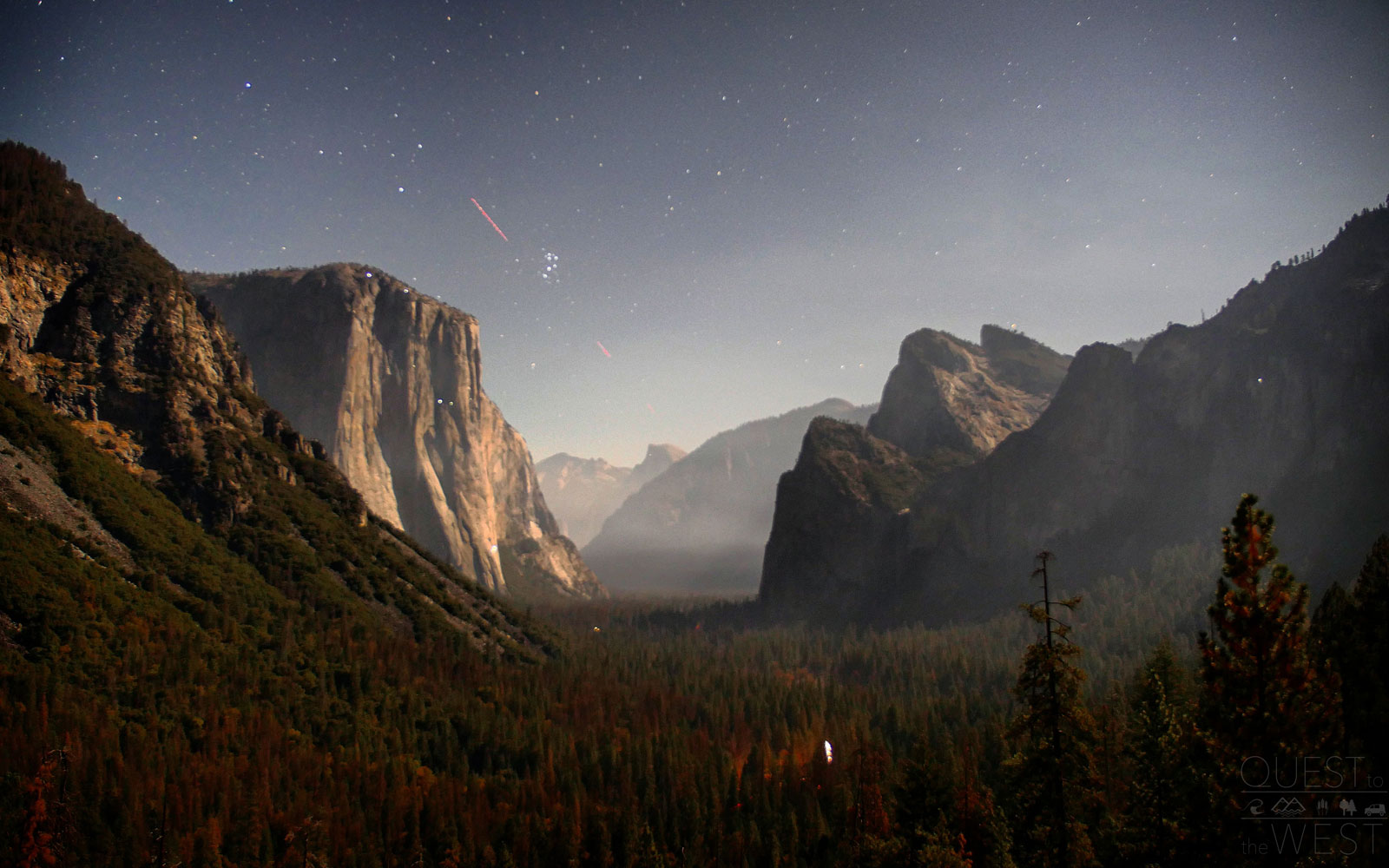
Yosemite National Park at Night — California
Paquette found that admiring California’s Yosemite National Park at nighttime gives a view most tourists rarely see.
“You look up in the sky and there’s just all these stars, but you’ve also got a little bit of light that comes in from a village that’s near campgrounds as light peeks in from the trees, and from the distance you can see mountain climbers scaling up and down El Capitan with their headlamps, but it feels like there’s no one out there” Paquette describes.
The park has 13 different campgrounds, so you have many options for enjoying the cascading waterfalls, giant sequoias, and vast meadows by day and star-speckled skies during the night.
Courtesy of Nick Paquette
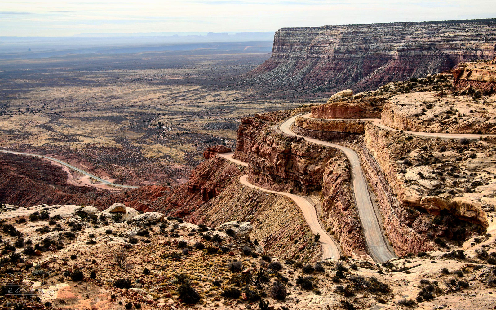
Moki Dugway — Utah
The Moki Dugway, which is located at the western end of the Valley of the Gods road, a graded dirt switchback road carved into the edge of Cedar Mesa.
The unpaved and steep roads can be dangerous and should be approached with caution, but many tourists brave the drive for the end result. From the top, visitors are treated to sweeping views over the Valley of the Gods (famous for its buttes and towering pinnacles) and Monument Valley in the distance.
“You get an amazing 180-degree view of the entire valley that’s just filled with red and orange rock formations throughout,” Paquette recalled.
Courtesy of Nick Paquette
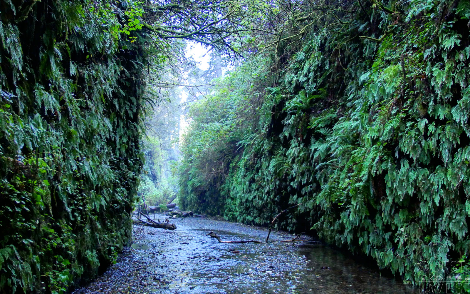
Fern Canyon — Prairie Creek Redwoods State Park, California
A love of dinosaurs led the duo to visit Fern Canyon in Prairie Creek Redwoods State Park, which was featured in Steven Spielberg’s “The Lost World: Jurassic Park.”
The stream canyon is covered in a variety of fern species and mosses that create hanging gardens and small waterfalls visitors can walk underneath.
In the summer, foot bridges are installed over the creek. Water trickles down the canyon walls covered in lush greenery, making for a tranquil setting.
“We saw a lot of canyons along our trip, but none that are full of vegetation like these,” Paquette said. “You’re just completely surrounded by all this greenery.”
Courtesy of Nick Paquette
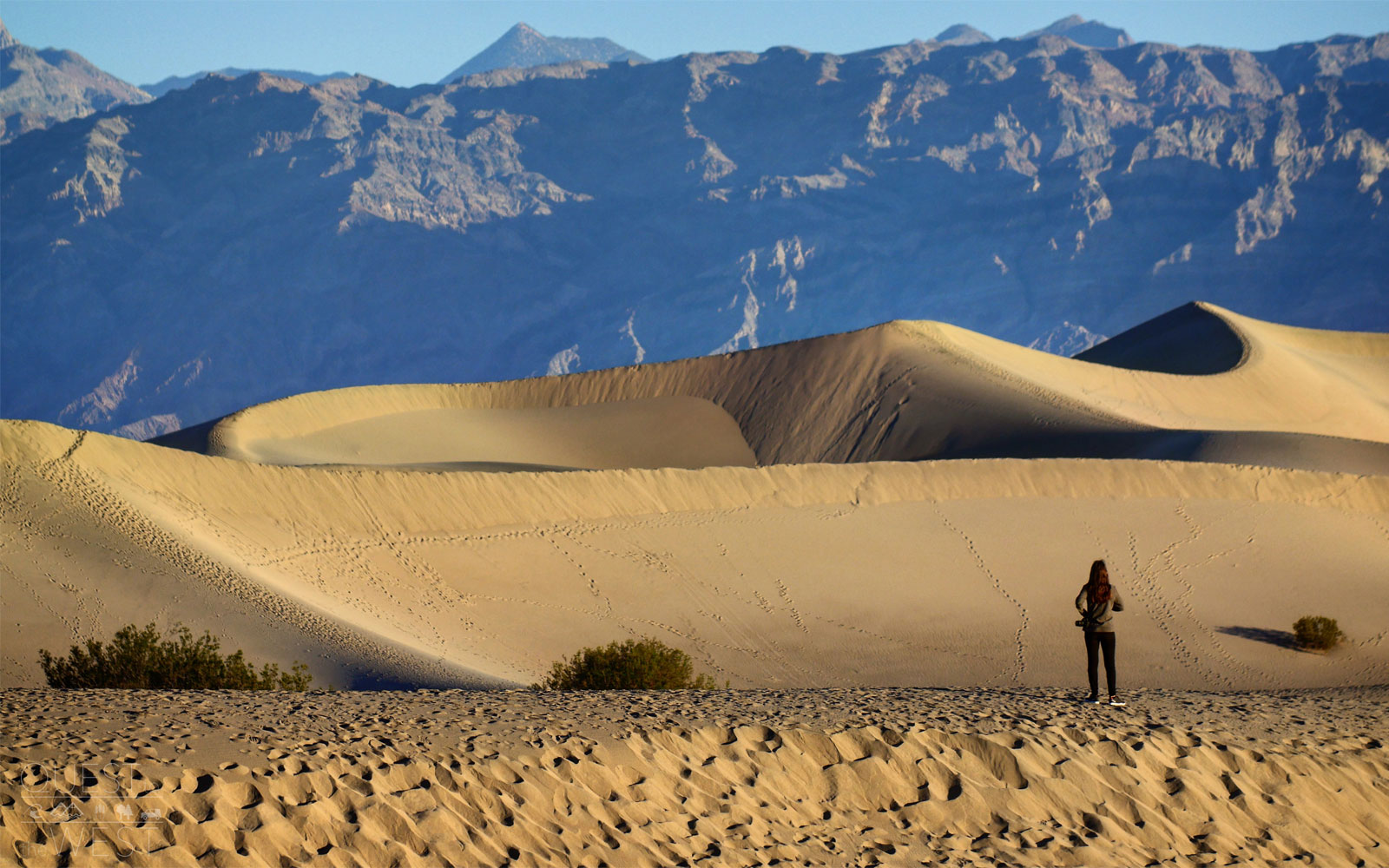
Death Valley National Park — California and Nevada
Death Valley National Park, which straddles California and Nevada, is America’s hottest, driest, and lowest national park. This allows the park to host a wide variety of landscapes for visitors to admire, making it Paquette’s favorite stop in the U.S.
“Just because of the sheer size of it, we could have spent two weeks here,” Paquette said.
“It’s strange because it’s a desert but it’s so diverse as you’ve got the Artist’s Palettemulticolored rocks, the huge sand dunes, and canyons you can hike through, but because it’s so huge it’s also really easy to get away and find your own space in the park,” he added.
One of his favorite stops in the park was the Mesquite Flat Sand Dunes, where Paquette spent his mornings.
“At sunrise you can sit on the dunes with your coffee and feel it start to warm up around you as the sun comes up,” Paquette said. “When you look down, you see all these traces from snakes and animals on the ground that scurry the area at night and retreat before the sun rises.”
Courtesy of Nick Paquette
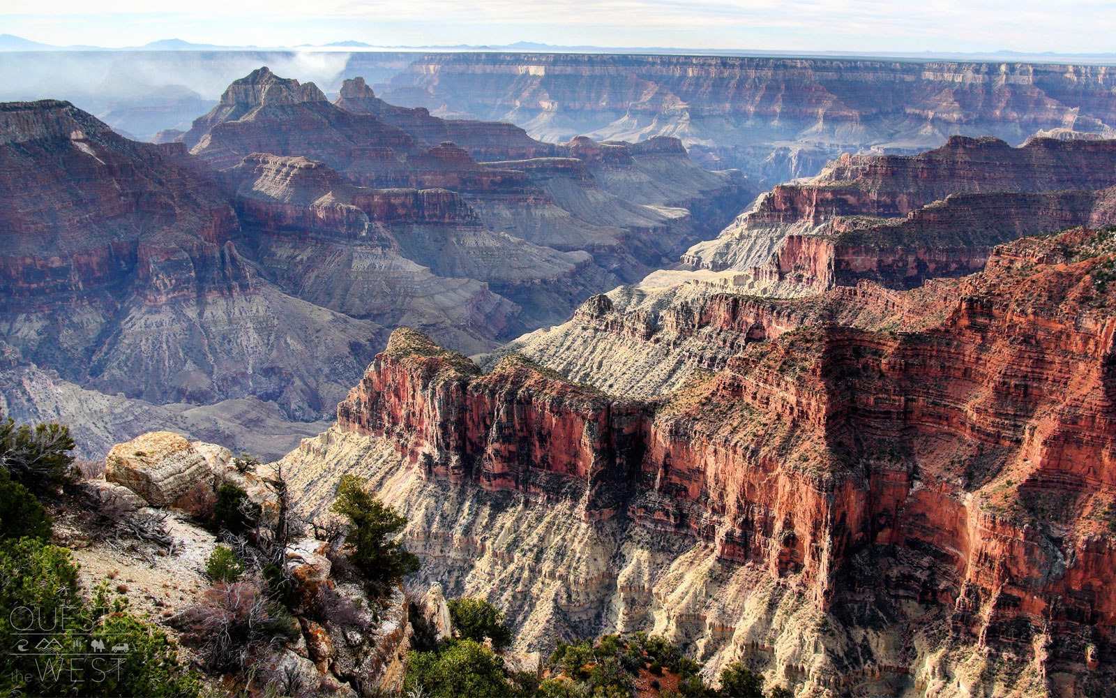
North Rim — Grand Canyon National Park, Arizona
Lack of crowds is the same reason Paquette recommends hitting the North Rim of the Grand Canyon because most travelers tend to go to the South Rim.
According to park representatives, the North Rim is only traversed by 10 percent of all of the parks visitors, with the hike from the South Rim to the North Rim spanning 21 miles.
Though it can be a trek to reach, the North Rim will reward you with breathtaking views over areas like the Painted Desert and panoramic views across the canyon both to the east and west.
Courtesy of Nick Paquette
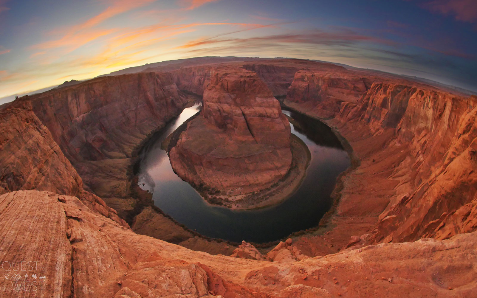
Horseshoe Bend — Arizona
Horseshoe Bend has become a popular attraction for travelers, and it’s one that Paquette says lives up to the hype.
“This place is one of the world’s most photographed locations, so it’s cool to get to check it off of the bucket list, but you only get a real sense of the scale when you see it in person,” Paquette noted. “It looks huge in the photo but you don’t really get a sense of how deep it is until you’re right there in front of it,” he added.
The bend in the Colorado River is located about 140 miles from Grand Canyon’s North and South Rims and is visible from a steep cliff that’s accessed through a short hike off U.S. Route 89.
Courtesy of Nick Paquette
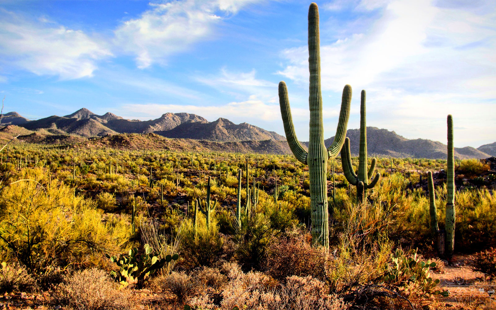
Saguaro National Park — Arizona
Paquette chose to visitSaguaro National Parkbecause of its surprising landscape.
“The landscape is completely different and I don’t think people really realize how high the cacti grow until you’re actually there in person,” he said of the park’s signature saguaro.
The saguaro are considered the nation’s largest cacti and are only found in select parts of the U.S., making the park one of few locations you can take in their size. Some of the cacti rise as high as 50 feet, according to park representatives.
If you’re there in the summer, make sure to take a peek at the cacti at night. During this time of the year, the cacti sprout flowers that bloom from their trunks and arms each night.
Courtesy of Nick Paquette
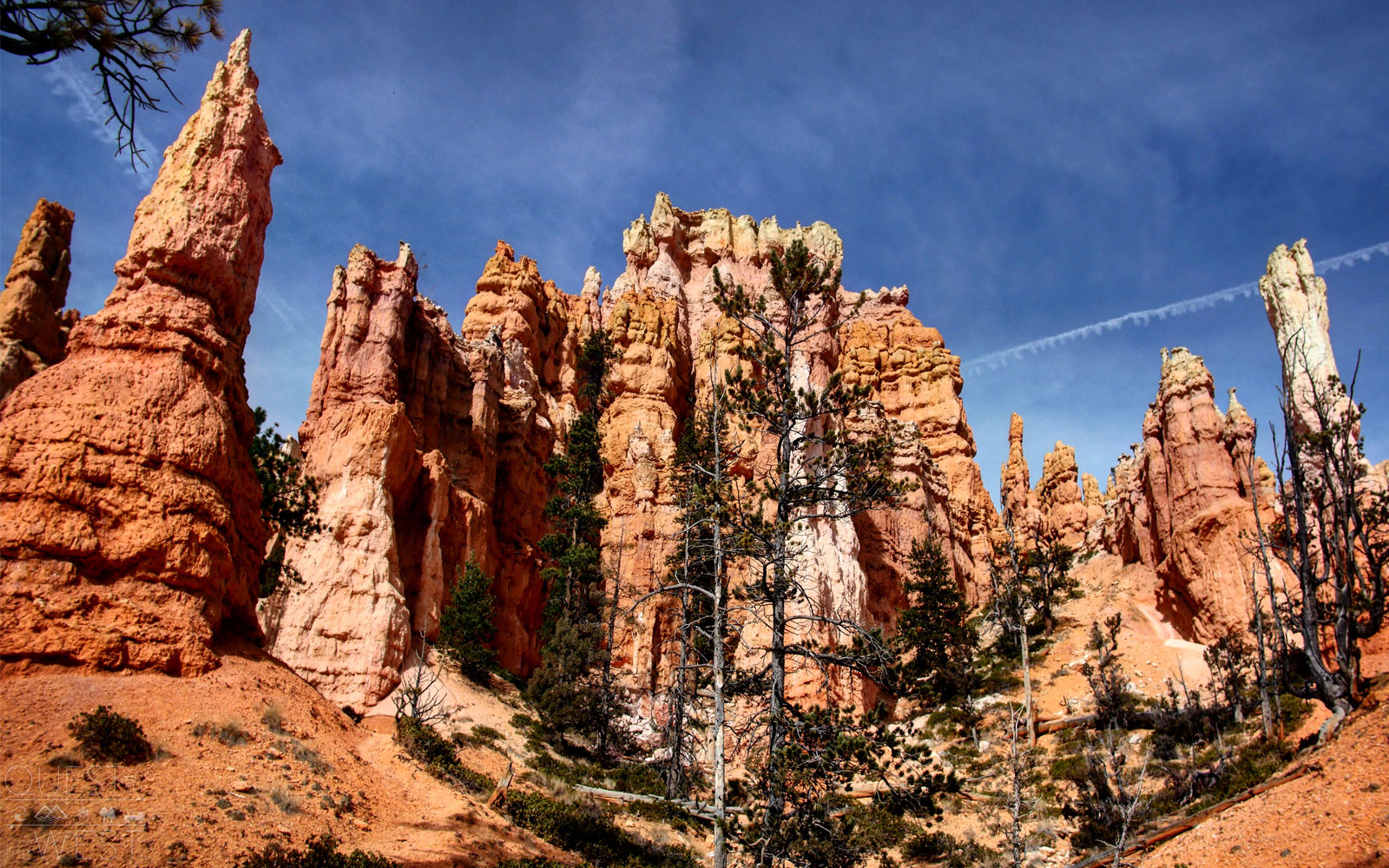
Queen’s Garden — Bryce Canyon National Park, Utah
One of Paquette’s top spots in Bryce Canyon National Park is the Queen’s Garden Trail, where you’ll spot a variety of the area’s famed hoodoos (tall and slender rock spires that jut out from the bottom of arid basins). One of the hoodoos at the end of the trail even looks like Queen Victoria, making it appear as though she is overlooking the garden.
“When you walk through, it feels like you’re in a giant castle as you see all these rock formations around you,” Paquette said of the site.
The trail is a simple one, according to park representatives, making it an easy way to start exploring the park.
Courtesy of Nick Paquette
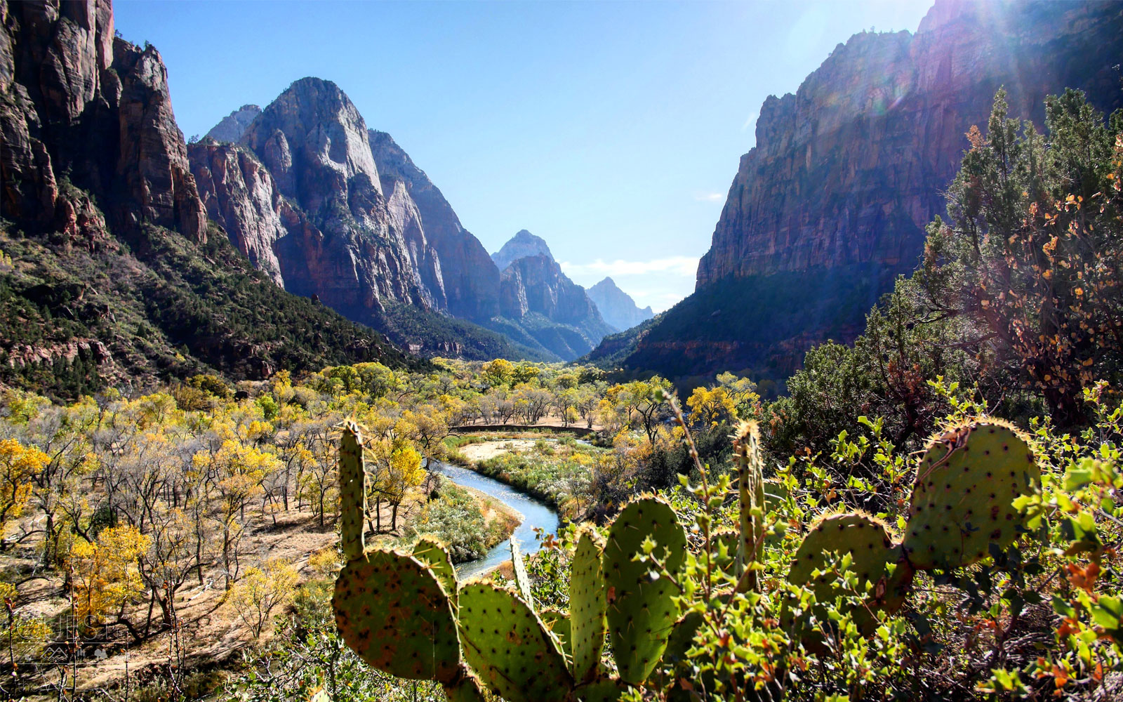
Zion National Park — Utah
Paquette also recommends exploring Zion National Park, which was Utah’s first national park and is home to narrow slot canyons, a variety of massive sandstone cliffs that range in color, and trails that lead to mesmerizing views.
Two of the most popular trails are: the Narrows, which takes hikers into the narrow section of Zion Canyon with walls reaching up to 1,000 feet, and Angel’s Landing, a five-mile path that runs along a narrow rock fin and showcases top views of the park from every direction.
Courtesy of Nick Paquette
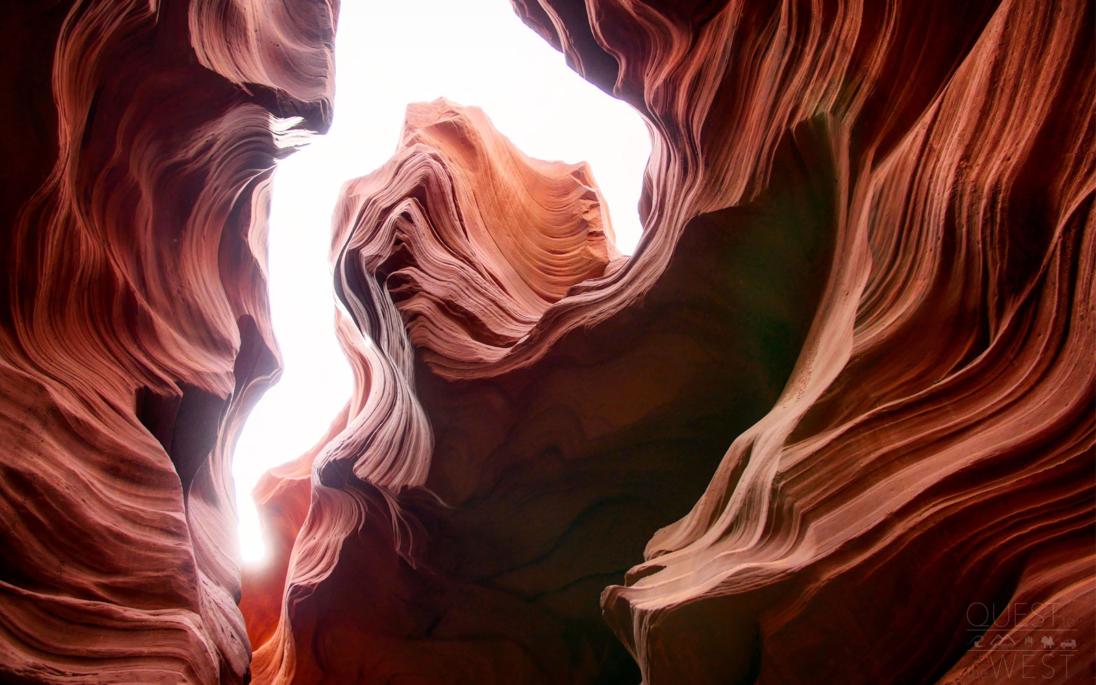
Lower Antelope Canyon— Page, Arizona
Antelope Canyon is made up of two different slots, both of which sit on Navajo lands. The Upper Canyon tends to be the more popular destination because visitors need to climb across multiple ladders to access the Lower Canyon.
That being said, it might be worth the trek to explore the less-traversed narrow canyon so you can take in the scenery at a more relaxed pace and get a better opportunity to capture some photographs.
“Everything looks like waves the way the light shines through the canyon; you can just point and shoot anywhere and every photo comes out incredible” Paquette said.
This article originally appeared on TravelandLeisure.com

More Must-Reads From TIME
- The 100 Most Influential People of 2024
- The Revolution of Yulia Navalnaya
- 6 Compliments That Land Every Time
- What's the Deal With the Bitcoin Halving?
- If You're Dating Right Now , You're Brave: Column
- The AI That Could Heal a Divided Internet
- Fallout Is a Brilliant Model for the Future of Video Game Adaptations
- Want Weekly Recs on What to Watch, Read, and More? Sign Up for Worth Your Time
Contact us at letters@time.com